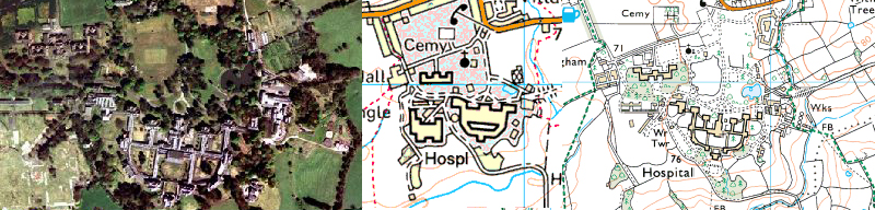
Three maps of Whittingham showing the various layouts. To the top left can be seen the long staggered
layout of the first wards we encountered, with their roofs removed, and heavily vandalised.
The Chapel and pond are both clearly marked.
The main areas are:
- St. Luke's Division - the main asylum with curved southerly corridors. It was surrounded by fencing.
- Cameron House Division - annex wards located north west of of St. Luke's. These buildings were missing their roofs.
- St. Margaret's Division - another huge, sprawling ward block. This was to the west of St. Luke's but has now gone.
- St. John's Division - these wards were to the north east of the site and have long been demolished.
It appears that only the church of St. John is listed - which is a shame. Development is ongoing to the north of the site,
with new houses being built in the grounds.
Multimap shows the scarred remains of The St. Margaret’s Division, still present on the second map, but gone
on the third.
And the third map shows St. Luke’s Division clearly, with the Superintendent’s House clearly visible to the
south.
The Roofless Wards. Impressive, until we found the hospital proper.
The Chapel. Exploring the exteriors of The Church Of St. John
Weighbridge. No-one ripped off Whittingham with coal deliveries.
First Ward. Complete with grim curtains.
The Admin Block. So shiny it looked like new.
Duck Pond. Never, ever, feed the geese.
The Boiler House. And no pictures of any boilers unfortunately.
The Nurses' Accomodation. Various houses and accommodation blocks.
St. Margaret's Division. I remember when all this was buildings.
The Water Tower. Modern and closed.
Second Wards. The western wards of the St. Lukes Division.
Superintendent's House. The only asymmetric building on the site.
Third Wards. The eastern wards of the St. Lukes Division.